


Nainital is a city and headquarters of Nainital district of Kumaon division, Uttarakhand, India. It is the judicial capital of Uttarakhand, the High Court of the state being located there and is the headquarters of an eponymous district. It also houses the Governor of Uttarakhand,[7] who resides in the Raj Bhavan. Nainital was the summer capital of the United Provinces.
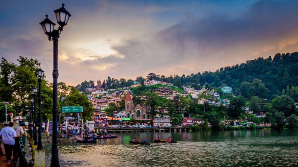
Nainital is located in the Kumaon foothills of the outer Himalayas at a distance of 285 km (177 mi) from the state capital Dehradun and 345 km (214 mi) from New Delhi, the capital of India. Situated at an altitude of 1,938 metres (6,358 ft) above sea level, the city is set in a valley containing an eye-shaped lake, approximately two miles in circumference, and surrounded by mountains, of which the highest are Naina Peak (2,615 m (8,579 ft)) on the north, Deopatha (2,438 m (7,999 ft)) on the west, and Ayarpatha (2,278 m (7,474 ft)) on the south. From the tops of the higher peaks, “magnificent views can be obtained of the vast plain to the south, or of the mass of tangled ridges lying north, bound by the great snowy range which forms the central axis of the Himalayas.” The hill station attracts tourists around the year.
Mussoorie is a hill station and a municipal board, near Dehradun city in the Dehradun district of the Indian state of Uttarakhand. It is about 35 kilometres (22 mi) from the state capital of Dehradun and 290 km (180 mi) north of the national capital of New Delhi. The hill station is in the foothills of the Garhwal Himalayan range. The adjoining town of Landour, which includes a military cantonment, is considered part of “greater Mussoorie”, as are the townships of Barlowganj and Jharipani.
Mussoorie is at an average altitude of 2,005 metres (6,578 ft). To the northeast are the Himalayan snow ranges, and to the south, the Doon Valley and Shiwalik ranges. The second highest point is the original Lal Tibba in Landour, with a height of over 2,275 m (7,464 ft). Mussoorie is popularly known as The Queen of the Hills
Jim Corbett National Park is a national park in India located in the Nainital district of Uttarakhand state. The first national park in India, it was established in 1936 during the British Raj and named Hailey National Park after William Malcolm Hailey, a governor of the United Provinces which it was then located. In 1956, nearly a decade after India’s independence, it was renamed Corbett National Park after the hunter and naturalist Jim Corbett, who had played a leading role in its establishment and had died the year before. The park was the first to come under the Project Tiger initiative.
Corbett National Park comprises 520.8 km2 (201.1 sq mi) area of hills, riverine belts, marshy depressions, grasslands and a large lake. The elevation ranges from 1,300 to 4,000 ft (400 to 1,220 m). Winter nights are cold but the days are bright and sunny. It rains from July to September. The park has sub-Himalayan belt geographical and ecological characteristics. Dense moist deciduous forest mainly consists of sal, haldu, peepal, Rohini and mango trees. Forest covers almost 73% of the park, while 10% of the area consists of grasslands. It houses around 110 tree species, 50 species of mammals, 580 bird species and 25 reptile species.
An ecotourism destination, the park contains 488 different species of plants and a diverse variety of fauna. The increase in tourist activities, among other problems, continues to present a serious challenge to the park’s ecological balance.
(source from wikipedia)
Please do not hesitate to call us in case of any query.
Hoping with best co-operation & waiting for your earliest reply.